The South West Coast Path National Trail
At 630 miles long, the South West Coast Path is Britain’s longest National Trail. It stretches from Minehead in Somerset to Poole Harbour in Dorset, taking in the coast of Devon and Cornwall. With rugged cliffs rising from the sea and waves lapping against sandy shores, the trail is extremely popular and many people choose to walk the entire route. The South West Coast Path encompasses some of the finest coastal landscapes in England and Wales, including Dorset’s Jurassic Coast, Land’s End in Cornwall, and Exmoor in Devon. The trail also gives walkers the chance to explore pretty fishing villages.
Dogs are actively welcomed on the South West Coast Path — you will stumble across an array of dog-friendly beaches, pubs, cafés, and other attractions along the path. However, remember to keep your pet under close control near cliff edges.
The Brixham and Berry Head circular walk on the south Devon coast — featured here was recommended by the South West Coast Path team as a great introduction to the trail and its stunning views. Berry Head is a prominent landmark in this part of Devon.
For further information on the South West Coast Path visit www.southwestcoastpath.com
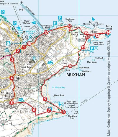
The walk
1. The walk begins at the William of Orange statue in Brixham, which is close to the town’s tourist information centre and the replica of the Elizabethan ship, the Golden Hind. The statue was built in the Victorian era to commemorate the landing of William of Orange — later King William II — in Brixham in 1688.
2. Turn up Fore Street, opposite the statue, walking past the Blue Anchor Inn and along the pedestrianised part of the street. You are now in the centre of bustling Brixham where many shops and banks are situated. The original town was based further inland.
3. When you get to the traffic lights at the end of the road, turn left on to Bolton Street. Continue going straight to another set of traffic lights. Walk straight ahead on to Greenwood Road. You will see Higher Brixham Church ahead; this marks the site of the original town centre which was positioned away from the coast for protection.
4. You will pass Brixham Hospital on your left, then take the next turning on the left, Castor Road. Follow the road ahead; the road levels out at the junction with St Mary’s Road — you will see a large tree in the middle of the junction.
5. Turn left here, walking along St Mary’s Road and following it as it bends to the left. Fork right at the junction just after South Bay Holiday Park. Keep going straight on. The road eventually becomes an unsurfaced green lane.
6. Follow the lane and go through a kissing gate, where the track turns to the left and narrows. When you get to another kissing gate, go through it and bear left. You will come to an open field with the coast on your right. Walk straight on and branch right towards a gate ahead.
7. The walk has now reached the South West Coast Path, which is followedback to Brixham. You are on the south side of Sharkham Point — a spot with stunning views along the coast to Scabbacombe Point. Stop to admire the views, the greenery and wild flowers, and take in the tranquil atmosphere. There are a couple of benches here if you want to sit and rest for a while.
8. Follow the coast path around Sharkham Point. This spot offers more breathtaking coastal views, as well as picnic facilities and car parking.
9. Go through another kissing gate on to a green lane and turn right. Follow this path, signposted Berry Head, as it climbs steadily up the cliff and skirts the rear of St Mary’s Bay between the two headlands.
10. Continue to follow the coast path — keeping right at the junction to continue along the cliff top — behind Durl Rock, which protrudes from the cliff. You will come to a couple of wooden stiles, one of which has an opening at the bottom for dogs. The path soon rises towards some stone ramparts ahead. Turn left when you arrive at a path in front of the ramparts. Follow this path to another T-junction.
11. At the T-junction, turn left and follow the path along the cliff top. The route continues towards the main headland at Berry Head.
12. Walk towards the entrance to the main fortifi cations on Berry Head. The apparatus on your left is a radio navigational aid, forming part of the UK’s Air Traffic Control system, which covers a range of 80 nautical miles.
13. At the junction at the fort gate, turn right into the fort. If all the walking and climbing has made you thirsty, stop for a pit stop at thedog-friendly Guardhouse Café. My Cocker Spaniel, Henry, received lots of fuss from staff and was given some doggy biscuits — well appreciated after our walk. There were several other dogs inside the café.
14. Walk to the end of the headland where you will discover more breathtaking and awe-inspiring views. At the end of the headland, the view encompasses the whole of Tor Bay and beyond to the red cliffs of the East Devon coast. In the opposite direction, you can look out back to Sharkham Point with Scabbacombe Head beyond. Berry Head lighthouse on your left was built in 1906. The lighthouse has a reputation for being the highest and lowest lighthouse in the country; the highest because it is built at a height of 60m, or nearly 200ft, above sea level, and the lowest because it is only 45m (15ft) high, to avoid being obscured by mist and low cloud.
15. When you’ve finished exploring the sights, return to the fort entrance and follow the path ahead. Bear right at the junction, following the sign to Brixham. Follow the path round the rear of old quarries as it becomes gravelled and descends through woods. Continue down some steps on your right which lead out on to a road. Turn right here. You’ll pass a hotel on the right. This was built as a military hospital during the Napoleonic period. It later became the home of the vicar of Brixham, Reverend H.F. Lyte, who wrote the famous hymn ‘Abide With Me’.
16. Keep walking straight along the road to the Shoalstone car park. Turn right here, walking through the parking area and down some steps, to a path above a swimming pool. Follow this path until it climbs back to the road. Turn right along the road. Keep an eye out for some steps opposite Devoncourt flats; go down these steps and walk to the end of Brixham breakwater. The breakwater — some 3,000ft in length — was built in 1893 and extended in 1909 and 1912.
17. When you reach the breakwater turn left and follow the path through the parking area behind the marina, signed to the town centre. Continue to the inner harbour.
18. Follow the path round to the right to return to the William of Orange statue at the start of the walk.
Walk facts
Terrain: Very hilly climbs in places. Well-maintained paths and roads. Several stiles and some steps.
Distance: 5. miles.
Time: Three and a half hours.
Off-lead opportunities: Plenty, but take care near cliff edges and livestock.
Toilets: Public toilets in Brixham. There are also toilets at the Guardhouse Café on Berry Head.
Suitable for: A moderate-level walk suitable for most people.
Site Content
Walk - Woodhuish and Mansands
Difficulty Moderate - Fairly level Coast Path, with some steep climbs either side of Mansands. Inland the lanes can be muddy.
Start Scabbacombe Lane Car Park - TQ6 0EF Finish Scabbacombe Lane Car Park Length 3.6 miles (5.8 km)
Summary
A short but steep circuit over high cliffs with spectacular views, dropping to the tiny shingle beach at Man Sands where the sea is being allowed to flood the reclaimed pastureland, creating a brackish lagoon where grass snakes are sometimes seen swimming with their heads out of the water, and many different birds come in to feed and to roost. The inland route follows ancient green lanes once used by farmers, fishermen and smugglers, and older children able to manage the steep hills will love the sense of adventure this walk brings. Wear good footwear, because the paths can be very wet and muddy.
Scabbacombe is dog-friendly all year. Have a look at our Top Dog Walks on the South West Coast Path for more dog-friendly beaches and pubs.
Public Transport
Buses go to Hillhead from Brixham or Kingswear. From the bus stop follow the Lower Ferry sign along the road, then turn left down Penhill Lane to join walk route at Mill Lane. For timetable information, zoom in on the interactive map and click on the bus stops, visit Traveline or phone 0871 200 22 33.
Nearest car park
National Trust car park, Scabbacombe Lane (Approximate postcode for Sat Navs: TQ6 0EF).
Nearest toilets
Public toilets by ferry slipway in Kingswear.
Walk information provided with help from Natural England. Map reproduced by permission of Ordnance Survey on behalf of HMSO. © Crown copyright and database right 2020. Ordnance Survey Licence number 100022021.
Route Description
- From Scabbacombe car park go through the gate to take the green lane downhill, signed ‘Scabbacombe Sands Link to Coast Path’. In the field follow the left-hand boundary to come out on the South West Coast Path above Scabbacombe Sands. Detour right to visit the beach.
- On the Coast Path turn left, climbing steeply over the cliffs to walk high above Long Sands for about a mile before dropping gently downhill to Man Sands.
The coastguard cottages above Man Sands were built by Napoleonic prisoners of war at the beginning of the nineteenth century. After the French Revolution towards the end of the previous century, Napoleon's armies had invaded and conquered much of Europe, triggering a series of conflicts as a number of different coalitions between the other European nations sought to prevent the spread of French power. French prisoners-of-war were put to good use in various ways around England, building Dartmoor Prison as well as many smaller constructions like these cottages.
The coastguard service was originally set up to prevent smuggling, which was widespread along this coast in the seventeenth and eighteenth centuries. The Coastguard Service Act 1856 stated that the aims of the service were 'to provide for the defence of the coasts of the realm, the more ready manning of the Royal Navy in the event of war or emergency, and the protection of the revenue'. It was not until 1911 that the Admiralty Coastguard Instructions ordered that 'at places where Coastguardsmen are stationed, such Coastguardsmen are to render every possible assistance to the local life-saving services as far as is compatible with their proper duties.'
Down on the beach, the prisoners-of-war also built the boathouse and the lime kiln. The latter is one of many dotted around the south-west coast and was designed to burn limestone and coal together to make lime, which was used as an agricultural fertiliser.
- Ignoring Woodhuish Lane on your left, (unless you wish to avoid the possibility of wet feet ahead), carry on across the shingle bar dividing the lagoon from the sea to the footpath beyond it. Turn left onto the path to head up Mansands Lane, rising gently above the lagoon and the stream that feeds it.
When the seawall was being built in 1986, workers discovered the grave of a young man thought to have been the victim of a shipwreck in an earlier century. In the middle of the nineteenth century the Reverend Hawker of Morwenstow, on the North Cornwall coast, instigated the practice of giving the victims of shipwrecks a decent Christian burial, but before this, their bodies were either left on the shoreline or buried somewhere just above it.
The pastureland behind the beach was reclaimed from the sea, and in 1985 steel gabions were erected in front of it to protect it from rising sea levels. In 2004, however, the National Trust (who own the land) decided to remove these wire baskets of rocks and let the sea flow inland, re-establishing the wetlands which had been drained in the first place to create the farmland. The resultant environment is one of the country's fastest-changing habitats as a result. In 2007 severe gales breached the shingle barrier dividing the lagoon from the sea, changing the mix of saltwater from the sea and freshwater from the river, and the wildlife on the lagoon altered as a result.
Recent bird visitors include waterbirds such as tufted ducks, coots and moorhens, as well as long-beaked shoreline scavengers like sandpipers, oystercatchers and ringed plovers. Swallows, house martins and sand martins dart at high speeds over the water's surface in pursuit of insects. The moist soil around the lagoon is equally good for plant life, and flowers to be seen in the area include early purple orchid, the tiny white star-like flowers of greater stitchwort and the big open heads of the oxeye daisy. Look out, too, for the tall stands of prickly teasel, once used for teasing out the strands of woven fabric. On the cliffs above Scabbacombe Sands there is a colony of fulmars, gull-like birds who live out on the open ocean but come back to the coast to breed, and in Woodhuish Farm, above, the organic and traditional methods of farming have encouraged the return of barn owls and greater horseshoe bats.
- At the top turn left onto Mill Lane, descending to the stream at the bottom. Crossing the footbridge ignore the footpath that climbs the hill to your left, instead continuing ahead along the lane as it follows the stream to meet Penhill Lane as it arrives from the right.
These lanes are part of an extensive and complex network of ancient green lanes, some of which date back to the Bronze Age, 4000 years ago. Until the coastline came under the protection of the coastguard service, frequent raids by pirates made it unsafe to live too close to the shore, and so settlements grew up a mile or two inland. The sea was an important part of everyday life, though, and for thousands of years farmers and fishermen, as well as smugglers, made frequent journeys to and from the shoreline along these very lanes.
In 2002 South Hams District Council launched an initiative to restore its 191 such green lanes, which together cover a staggering 300km. By 2005 it had raised £26,000, with 62 local businesses contributing to the scheme, enabling the council to tackle more than half the lanes, repairing erosion damage, laying hedges and conserving hedgebanks and setting up links to nearby towns and villages. Because these lanes are traffic-free and only lightly maintained they too are a haven for plants, birds and other wildlife.
- Turn sharply left here, crossing the stream and turning sharp left again to head uphill to Woodhuish Lane.
- At the top turn right and follow the road back to the car park at the start of the walk.
